


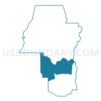
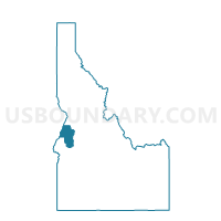
Voting District 003002, Adams County, Idaho
About
Outline

Summary
| Unique Area Identifier | 563670 |
| Name | Voting District 003002 |
| County | Adams County |
| State | Idaho |
| Area (square miles) | 204.27 |
| Land Area (square miles) | 203.82 |
| Water Area (square miles) | 0.44 |
| % of Land Area | 99.78 |
| % of Water Area | 0.22 |
| Latitude of the Internal Point | 44.70584230 |
| Longtitude of the Internal Point | -116.43620480 |
Maps

Graphs
Select a template below for downloading or customizing gragh for Voting District 003002, Adams County, Idaho


Neighbors
Neighoring Voting District (by Name) Neighboring Voting District on the Map
- Voting District 003001, Adams County, ID
- Voting District 003003, Adams County, ID
- Voting District 003005, Adams County, ID
- Cambridge 8 Voting District, Washington County, ID
- Payette Voting District, Valley County, ID
Top 10 Neighboring County Subdivision (by Population) Neighboring County Subdivision on the Map
- McCall CCD, Valley County, ID (7,235)
- Cascade CCD, Valley County, ID (2,586)
- Council CCD, Adams County, ID (2,227)
- New Meadows CCD, Adams County, ID (1,749)
- Cambridge CCD, Washington County, ID (935)
Top 10 Neighboring Place (by Population) Neighboring Place on the Map
Top 10 Neighboring Unified School District (by Population) Neighboring Unified School District on the Map
- McCall-Donnelly Joint School District 421, ID (7,552)
- Council School District 13, ID (2,025)
- Cambridge Joint School District 432, ID (1,147)
Top 10 Neighboring State Legislative District Lower Chamber (by Population) Neighboring State Legislative District Lower Chamber on the Map
Top 10 Neighboring State Legislative District Upper Chamber (by Population) Neighboring State Legislative District Upper Chamber on the Map
Top 10 Neighboring 111th Congressional District (by Population) Neighboring 111th Congressional District on the Map
Top 10 Neighboring Census Tract (by Population) Neighboring Census Tract on the Map
- Census Tract 9703, Valley County, ID (4,592)
- Census Tract 9701, Valley County, ID (2,627)
- Census Tract 9502, Adams County, ID (2,227)
- Census Tract 9501, Adams County, ID (1,749)
- Census Tract 9701, Washington County, ID (1,655)
Top 10 Neighboring 5-Digit ZIP Code Tabulation Area (by Population) Neighboring 5-Digit ZIP Code Tabulation Area on the Map
- 83638, ID (5,903)
- 83612, ID (1,925)
- 83615, ID (1,571)
- 83610, ID (946)
- 83632, ID (214)
- 83643, ID (129)